Enabling Country-Scale Land Cover Mapping with
Meter-Resolution Satellite Imagery
Xin-Yi Tong, Gui-Song Xia, Xiao Xiang Zhu
The Five-Billion-Pixels dataset is released!
The coordinate information of Five-Billion-Pixels is now available!
The test data for land cover mapping is released!
The code and model for land cover mapping is now available!
Introduction
High-resolution satellite images can provide abundant, detailed spatial information for land cover classification, which is particularly
important for studying the complicated built environment. However, due to the complex land cover patterns, the costly training sample collections,
and the severe distribution shifts of satellite imageries caused by, e.g., geographical differences or acquisition conditions, few studies have
applied high-resolution images to land cover mapping in detailed categories at large scale. To fill this gap, we present a large-scale land cover
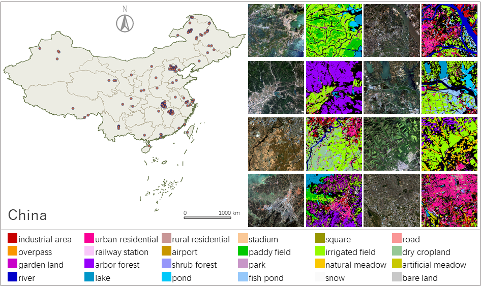
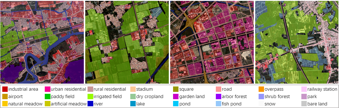
dataset, Five-Billion-Pixels. It contains more than 5 billion labeled pixels of 150 high-resolution Gaofen-2 (4 m) satellite images,
annotated in a 24-category system covering artificial-constructed, agricultural, and natural classes. In addition, we propose
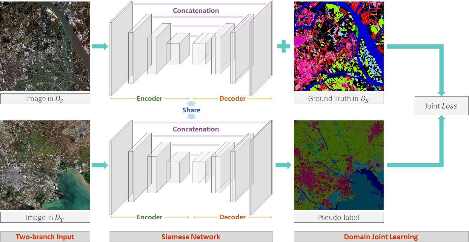
a deep-learning-based unsupervised domain adaptation approach that can transfer classification models trained on labeled dataset (referred to as
the source domain) to unlabeled data (referred to as the target domain) for large-scale land cover mapping. Specifically, we introduce an end-to-end
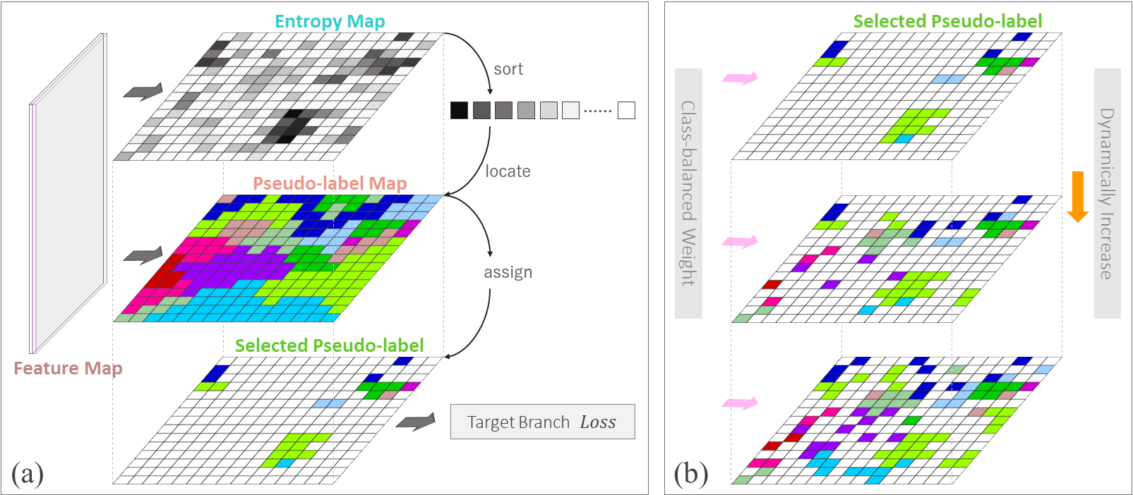
Siamese network employing dynamic pseudo-label assignment and class balancing strategy to perform adaptive domain joint learning. To validate the
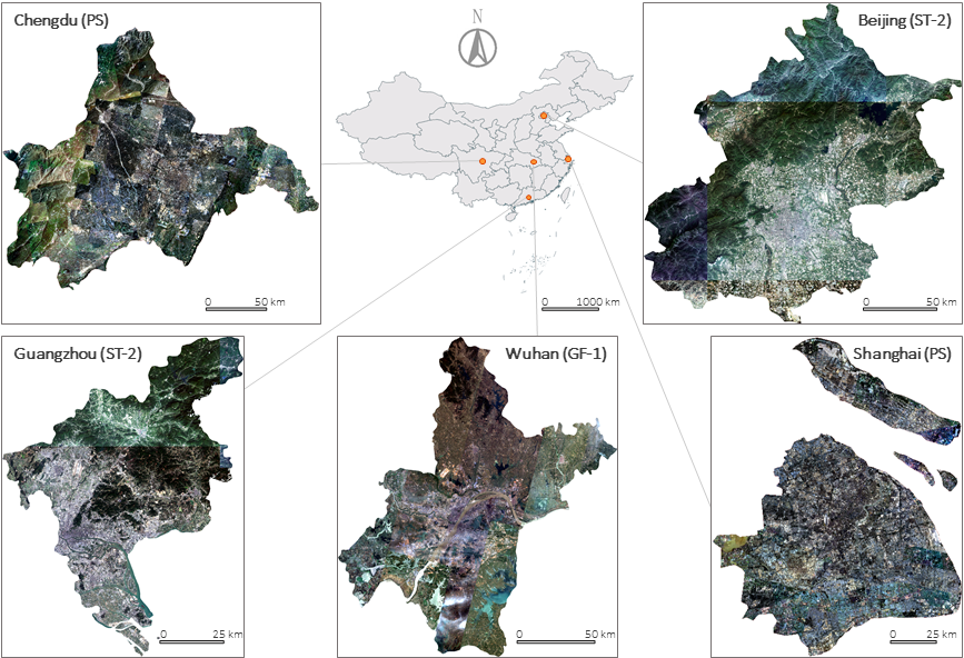
generalizability of our dataset and the proposed approach across different sensors and different geographical regions, we carry out land cover
mapping on five megacities in China and six cities in other five Asian countries severally using: PlanetScope (3 m), Gaofen-1 (8 m), and
Sentinel-2 (10 m) satellite images. Over a total study area of 60,000 square kilometers, the experiments show promising results even though the
input images are entirely unlabeled. The proposed approach, trained with the Five-Billion-Pixels dataset, enables high-quality and detailed
land cover mapping across the whole country of China and some other Asian countries at meter-resolution.
Five-Billion-Pixels
We present a large-scale land cover classification dataset, Five-Billion-Pixels. It has a spatial resolution of 4 m, covers areas
more than 50,000 square kilometers in China, and contains more than 5 billion labeled pixels. It possesses the advantage of rich
categories, large coverage, wide distribution, and high-spatial resolution, which well reflects the distributions of real-world ground objects and
can benefit to different land cover related studies.
Land Cover Mapping
We propose an unsupervised domain adaptation approach for practical large-scale land cover mapping. Concretely, we introduce an end-to-end
Siamese network consisting of two branches, which separately process images from the source and target domain. In the target domain branch, image
pixels with high-confidence are assigned with pseudo-labels and then utilized for domain joint learning with the source domain branch. To mitigate
negative adaptation, we adopt dynamic pseudo-label assignment and class balancing strategy in the network. Based on the proposed approach, we carry
out land cover mapping on five megacities in China and six cities in other five Asian countries severally using unlabeled PlanetScope (PS),
Gaofen-1 (GF-1), and Sentinel-2 (ST-2) satellite images. The encouraging results show the generality of our dataset and approach
across different satellites and regions.
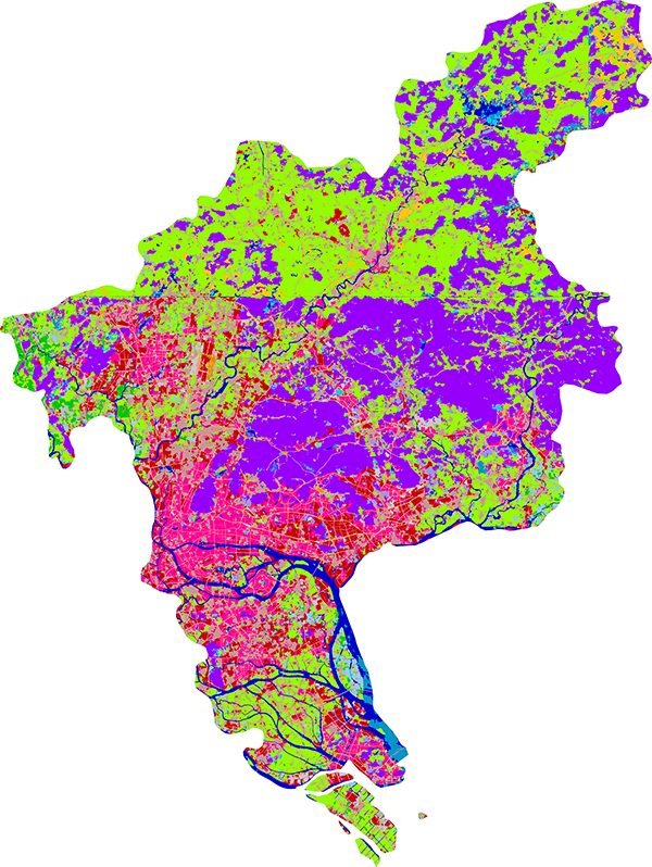
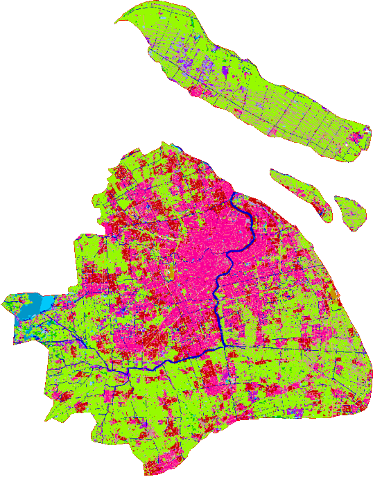
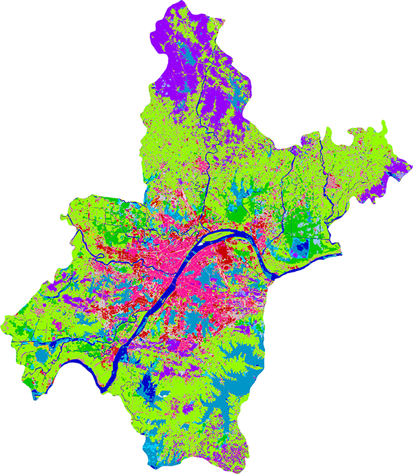
Result Demonstration
Due to the large size of resulting maps, only the central area of each city is shown.
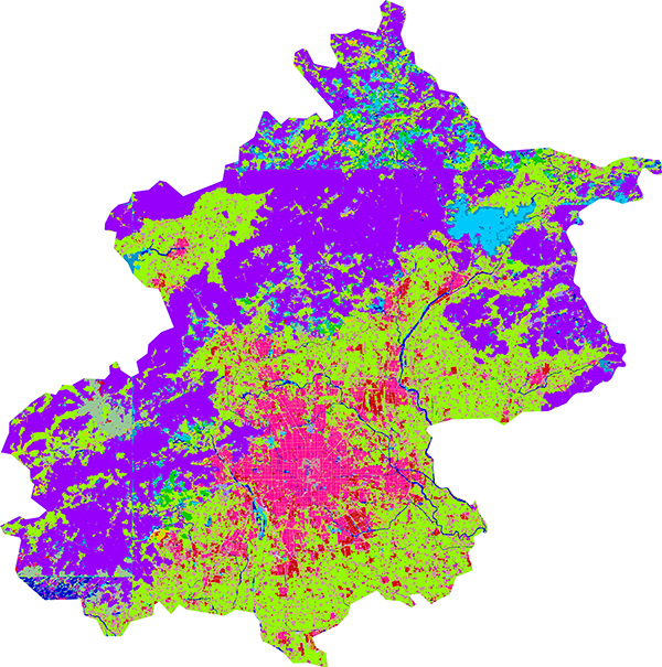
Beijing |
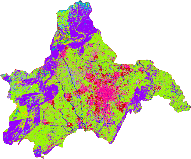
Chengdu |
Guangzhou |
Shanghai |
Wuhan |
Comparison with Google's Dynamic World and ESA's
World Cover in Beijing and Guangzhou (all use ST-2).

(a-b) Land cover map of central area of Beijing from Dynamic World and World Cover. (c) Our result of Beijing. (d-e) Land cover map of central
area of Guangzhou from Dynamic World and World Cover. (f) Our result of Guangzhou.
Citation
@article{FBP2023,
  title={Enabling country-scale land cover mapping with meter-resolution satellite imagery},
  author={Tong, Xin-Yi and Xia, Gui-Song and Zhu, Xiao Xiang},
  journal={ISPRS Journal of Photogrammetry and Remote Sensing},
  volume={196},
  pages={178-196},
  year={2023}
}
Contact
E-mail: xytong@mit.edu
Personal page: Xin-Yi Tong